by Jeremy Farquharson
Summary: A trip undertaken in Sept 2015 to Ithala Game Reserve; single vehicle, 3 different routes; two free, one paid for.
Ithala is a magic place to visit or stay at, irrespective of whether or not you are doing any 4x4 driving there. It has 4 of the Big Five, the missing one being lion. We spotted 3 of the 5, with only leopard being elusive as usual. One of the best hutted camps around, and some great campsites and bush lodges as well.
There are actually four 4x4 routes within the reserve, with the longest and likely most demanding route being available only to people occupying the Mhlangeni bush camp. The remaining three routes are open to all, though the Bivane Trail has to be pre-booked (R75 per car), and can accommodate a maximum of seven cars per day.
A: Bivane Trail: (Grade 2 with some Grade 3 bits - trail could be tricky in the wet)
Bivane 4x4 is the longest of the 3 "public" trails, being approx 8km in length, and is found in the NW corner of the Ithala reserve. You'll need low range and high clearance for this one. It's an "out and back" route, where you drive the same track in both directions. It's almost exclusively single-vehicle width, so you need to keep a constant lookout for vehicles coming in the opposite direction. There are several sections that would involve a fair bit of very tricky reversing for one or other of the vehicles. Ithala management do not apply their own policy about which vehicle has to give way - simply deal with it as and when it arises, and move the vehicle which can most simply get off the trail.
The route crosses a rocky stream bed right at the start, then winds and climbs for several km up a rocky, tree-covered hillside. The trees and bush are quite dense, so getting off the track is often difficult. Most of the climb is a rough gravel track with a middelmannetjie, and a hard substrate covered with loose rocks and pebbles. However, there are several steep sections with rock steps, though most of the steps are not very large. Some parts of the track involve tight climbing turns with bush encroaching tightly on both sides, as well as loose rocks. In dry conditions, these climbs and steps are fairly easy, but a wet trail may be a different proposition.
The trail climbs to a grassy nek, where a short section (200m) drops from a T-junction down to the right to a turning circle. Park there and walk to the top of a nearby koppie for 360 degree views of the Pongola River valley below. Retrace your steps, then turn right (downhill) at the junction. The track drops steeply down to the right over loose, rocky terrain, with big drop-offs to your left - no mistakes here, please. You'll eventually reach a flat open plain running next to the Pongola River itself. Great for a picnic, but stay clear of the river - crocs live here! Return via the same route. Remember to stop where views allow, to check for oncoming vehicles.
B: Dlabe Trail: (Grade 1-2)
This is a 4.1 km trail that joins two ends of the Ngubhu loop road which skirts below the cliff-line running along the SW and southern borders of the park. Very simple driving - pretty much a gravel road. Emerges near the Doornkraal campsite and Thalu Bush Camp, and the start of the Bivane 4x4 trail in the valley. In dry conditions, this could be done easily with a high-clearance 4x2.
C: Ntshamanzi Trail: (Grade 2 with one or two short grade 3 sections)
Much more fun! Quite rough in places, has a hard substrate, and lots of lovely loose gravelly / rocky stuff to clamber over. A number of short drops / climbs have quite large loose stones / small rocks to negotiate. This track drops into a remote, interesting and heavily-treed valley. Lots of birdlife, and elephant sometimes spotted there. The route emerges onto the tar road leading down to the Pongola River - (the Dakaneni loop.)
D: NceNce trail: (Grade unknown to me as I did not drive it, but apparently Grade 3-ish)
This one is available only to clients who have hired the Mhlangeni Bush Camp. About 23km in length and apparently tricky in some places. An Ithala guide is a compulsory passenger for this trail. Call Ithala Camp (034-983 2540) for more info.
E: Horace Rall viewsite: (Easy drive, though H4 is useful once on top in the grassland)
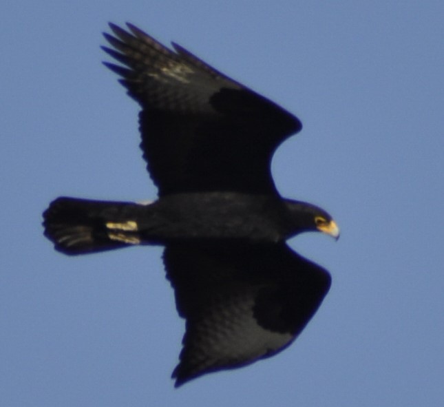
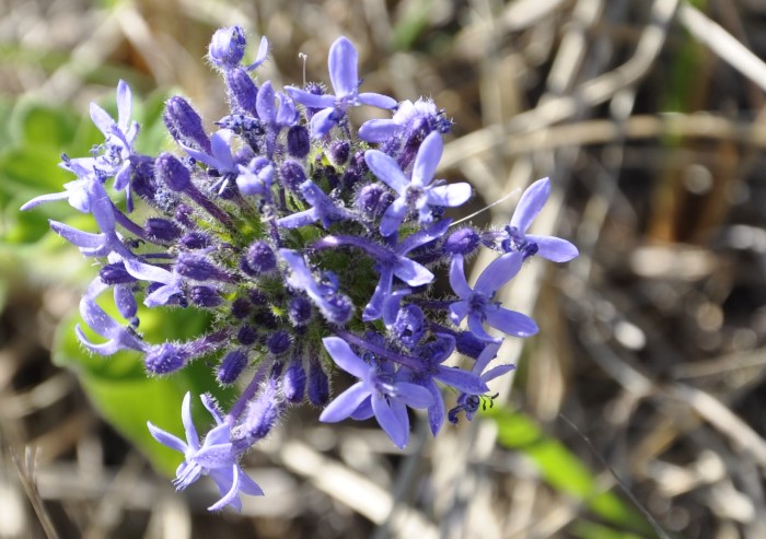
This drive is a MUST-DO!! Fetch the key for the access gate from Ntshondwe Camp reception. Drive out of the Ithala reserve, back up to Louwsburg village. At the 4-way stop on the main street in the village drive straight across and up the hill onto a concrete road built by the military in the 70s. Near the crest of the hill, turn right through a gated entry point (with no gate!!) The road doubles back on itself towards Louwsburg, but now runs along the crest of the mountain. About 2km later, once through the locked gate near the old comms station, you must close and lock the gate behind you. About 200m into the fenced area, turn right onto a grassy track near a copse of wattle trees, which takes you rightwards and up a low slope to the cliff-top view-site. The viewing platform offers incredible views across the entire reserve. We saw a pair of Black Eagle and a Jackal Buzzard close-up within 3 mins of our arrival at the viewsite. Also unusual / rare plant species - mostly montane belt species including beautiful wild flowers and succulents. You may come across a very rare kind of aloe - Aloe Vryheidii (ask Alan Smale, the camp manager, to show you these outside the reception area at Ntshondwe Camp) as well as a unique protea tree with yellow blooms. Don't miss this drive. - it's a fantastic 1.5 hour trip if in a hurry, and a place to linger and walk in for hours if time permits. Camera and binocs are compulsory. Don't forget to drop the key at reception once back in camp.
The "Budgie" is a bit blurry thanks to rapid flight, but....